Pilot plan
A small, accessible pilot
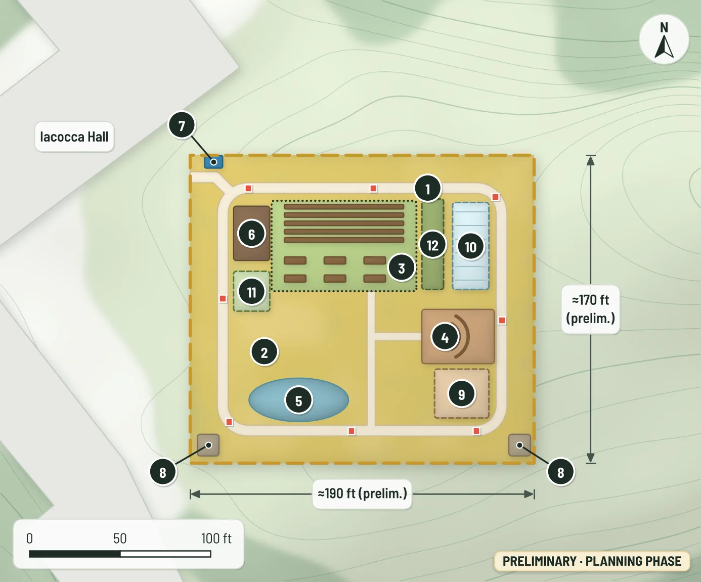
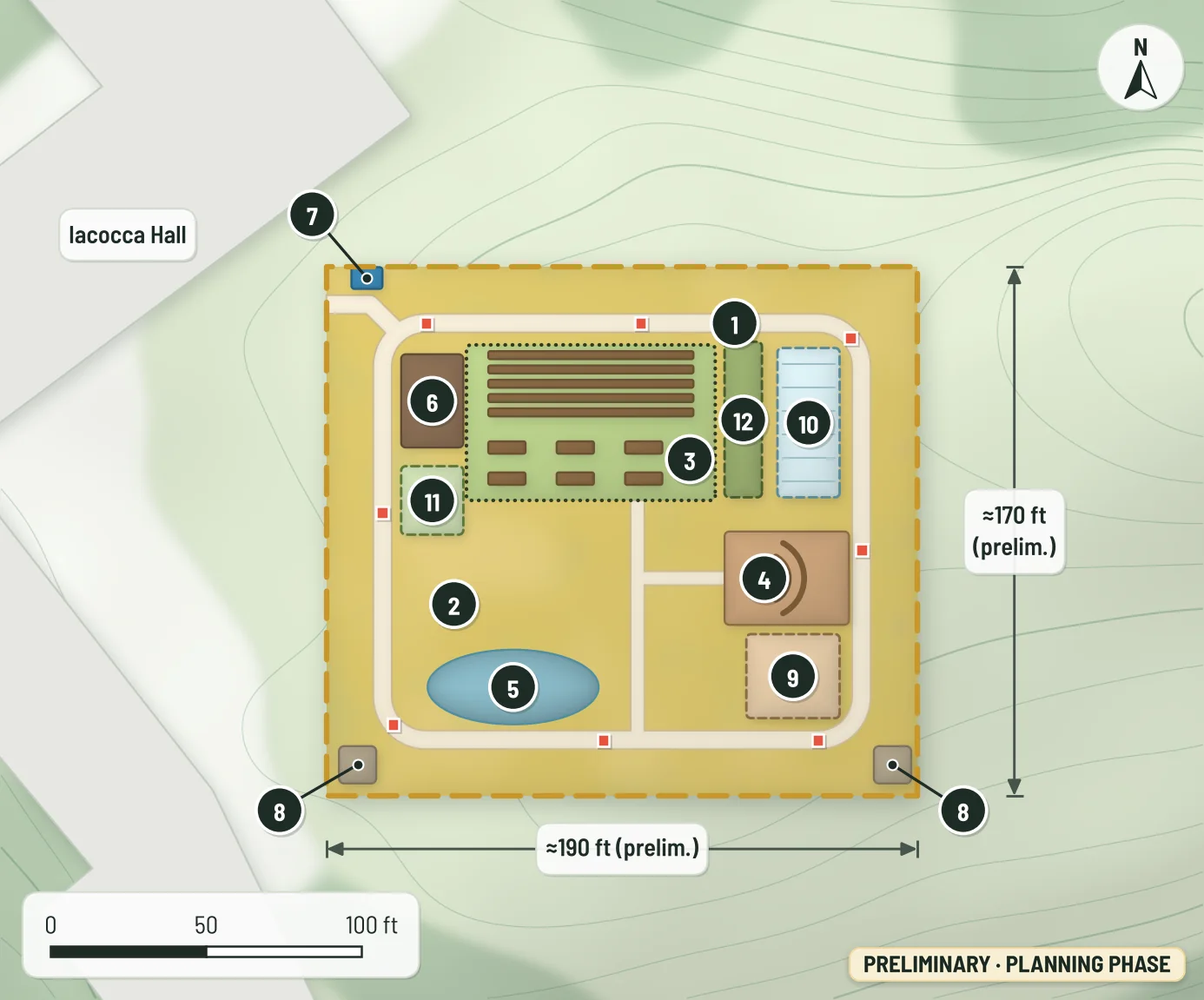
The pilot is illustrated at ≈0.74 acre (≈190 × 170 ft) and could range from 0.5 to 1 acre. It is drawn on the gentle terrace of Area 1, east of Iacocca Hall.
Illustrative plan
Key
- 1. Accessible loop6 ft wide, about 550 linear ft
- 2. Native pollinator meadow & bordersIncludes mown margins
- 3. Edible gardenDeer-fenced, about 80 × 50 ft, with 6 accessible raised beds
- 4. Outdoor classroom24–30 seats, about 40 × 30 ft
- 5. Rain gardenAbout 55 × 24 ft
- 6. Compost & tool yardRodent-resistant bins, about 20 × 30 ft
- 7. Water pointBottle filler and cistern; connection location to be confirmed
- 8. Quiet seating (2)About 12 × 12 ft each
- 9. Shaded picnic area (optional)About 30 × 27 ft
- 10. Unheated high tunnel (optional)About 20 × 48 ft
- 11. Seed nursery & cold frames (optional)About 20 × 22 ft
- 12. Native berry hedge (optional)About 12 × 50 ft
- Interpretive signs8, spaced around the loop
- Pilot study footprintAbout 190 × 170 ft, preliminary
Area schedule
Pilot area schedule (approximate, in square feet). Areas come from the same layout geometry as the plan PDF and are rounded.
| Feature | Preliminary size | Sq ft |
|---|---|---|
| Required | ||
| Meadow & borders, incl. mown margins | — | ≈18,400 |
| Edible demonstration garden | ≈80 × 50 ft | ≈4,000 |
| Accessible loop & entry | 6 ft wide | ≈3,450 |
| Secondary paths | 4–5 ft wide | ≈450 |
| Outdoor classroom | ≈40 × 30 ft | ≈1,200 |
| Rain garden | ≈55 × 24 ft | ≈1,040 |
| Compost & tool yard | ≈20 × 30 ft | ≈600 |
| Quiet seating (2) · water point | ≈12 × 12 ft each | ≈360 |
| Optional | ||
| High tunnel · picnic shade · berry hedge · seed nursery | 20 × 48 ft tunnel | ≈2,810 |
| Total pilot footprint | ≈190 × 170 ft | ≈32,300 (≈0.74 ac) |
Preliminary dimension guidelines
- Accessible routes 6 ft clear, with a target of no more than 5% running slope and 2% cross slope, on a firm and stable surface.
- Secondary paths 4–5 ft wide; aisles of at least 4 ft and 5 ft turning space at accessible beds.
- Accessible raised beds about 24–30 in high; deer fence about 8 ft; about 10 ft of clear service access, shared with the loop.
These are working targets for accessibility and code review, not final values. They must be confirmed against the 2010 ADA Standards and applicable codes by qualified reviewers.
The pilot in its setting
Credits: Base map: USDA NAIP 2017 imagery via USGS and USGS elevation. Building: © OpenStreetMap contributors (ODbL), Microsoft ML Buildings, via Overture Maps.
How the pilot could unfold
Phase 0 · 0–6 months
Lehigh review; confirm area, utilities, soils, accessibility and permit path; name a sponsor; baseline biodiversity survey.
Phase 1 · Year 1
Pilot core: meadow preparation and dormant-season seeding, accessible loop, edible beds, compost, rain garden, signs.
Phase 2 · Years 2–3
Optional items (high tunnel, picnic shade, seed nursery, berry hedge); review pilot use and upkeep.
Later phases are on Long-Term Possibilities. Costs have not been estimated; they would be prepared with Lehigh Facilities from verified unit costs.