Preliminary site study
Where a garden might fit
A desktop review of public maps, elevation data and aerial imagery found three possible study areas on the Mountaintop plateau. These are starting points for a conversation, not sites anyone has offered or given permission to use.
Site context map
Credits: Base map: USDA NAIP 2017 imagery via USGS. Contours, relief and slopes: USGS elevation. Buildings, roads and power line: © OpenStreetMap contributors (ODbL), Microsoft ML Buildings, via Overture Maps.
Text description of this image
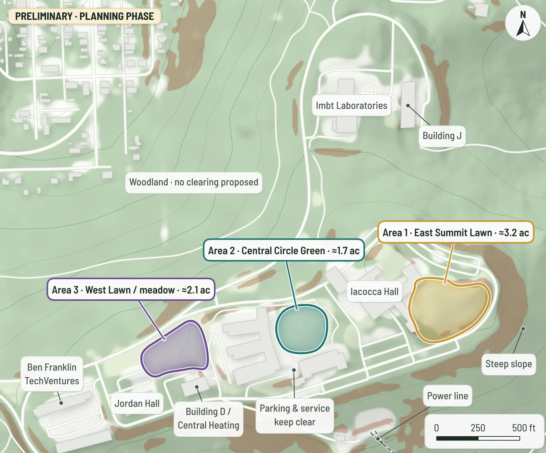
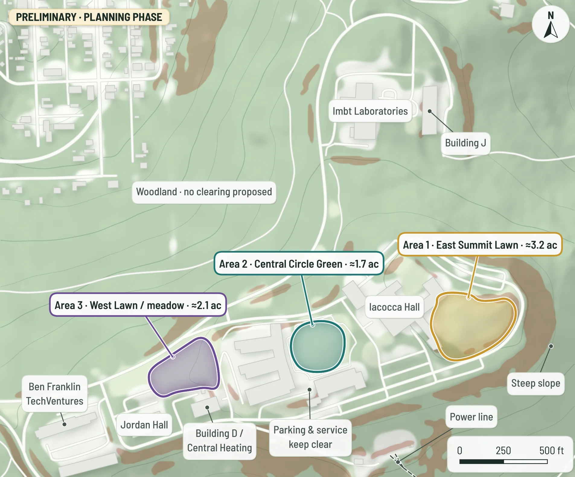
A simplified map of the top of the Mountaintop Campus, north up, with woodland all around. Imbt Laboratories and Building J are to the north and houses to the north-west. A label in the woodland reads “Woodland · no clearing proposed”.
Three study areas are outlined and tinted, each with a one-line label: “Area 1 · East Summit Lawn · ≈3.2 ac” in gold, east of Iacocca Hall; “Area 2 · Central Circle Green · ≈1.7 ac” in teal, a round lawn in the middle of the campus; and “Area 3 · West Lawn / meadow · ≈2.1 ac” in violet, just north of Building D / Central Heating.
Brown shading marks steep slopes around the plateau's edges. Other labels mark Jordan Hall, Ben Franklin TechVentures, parking and service areas to keep clear, and a short overhead power line at the bottom edge. A scale bar (0 to 500 ft) and a north arrow are at the right, and a chip at the top left reads “Preliminary · planning phase”.
Three possible study areas
Desktop estimates from public data. Not surveyed, not parcels, and not an indication that land is available.
| Study area | Open area | Elevation | Largest gentle ground* | What we found | Suggested role |
|---|---|---|---|---|---|
| 1. East Summit Lawn | ≈3.2 ac | ≈896–932 ft | ≈0.6 ac | Open lawn beside Iacocca Hall with mixed slopes; its largest continuous ground under about 8% slope is about 0.6 acre. It has a gentle terrace that could hold a compact, accessible pilot. | Proposed pilot study area |
| 2. Central Circle Green | ≈1.7 ac | ≈884–889 ft | ≈1.7 ac | The flattest open ground. It appears to be the event lawn beside Building C that Lehigh lists with a capacity of 500+ (Lehigh’s exact name for it is still to be confirmed). | Keep it open for events |
| 3. West Lawn / meadow | ≈2.1 ac | ≈835–865 ft | ≈0.8 ac | Lehigh reports converting part of a Mountaintop lawn to native meadow in summer 2021 but does not say where. Satellite data suggest it may be this area (a sharp greenness drop in September 2021 and meadow-like autumn colour since). To confirm. | Protect and keep as is |
*Largest continuous ground under about 8% slope, derived from USGS elevation data. Elevations are approximate (NAVD88).
What the desktop review found
- About 7 acres of open lawn or meadow lie on the plateau, in three separate areas (≈3.2, ≈1.7 and ≈2.1 acres).
- No contiguous 5–10 acre open site was found outside the woodland.
- The largest continuous ground under about 8% slope is ≈1.7, ≈0.8 and ≈0.6 acres (Areas 2, 3 and 1).
Because no single large open site exists without clearing woodland, the pilot plan is kept small, and the long-term possibilities are spread across separate areas.
Credits: Relief: USGS elevation. Roads, rivers and buildings: © OpenStreetMap contributors (ODbL), Microsoft ML Buildings and Esri Community Maps contributors (CC BY 4.0), via Overture Maps.
Known constraints
- Lehigh’s South Mountain woodland, Forest Park (≈760 acres), and a Lehigh lab’s 16 long-term forest research plots on Mountaintop. No tree removal is proposed.
- Steep plateau edges. City rules on disturbing slopes over 15% may apply (to confirm).
- An overhead power-line corridor to the southeast.
- Parking, service and bus operations around Iacocca Hall and Building C must stay clear.
- State erosion-control and city stormwater thresholds may apply to earthwork (to confirm).
What we still need to learn from Lehigh
- Is any area earmarked under Making the Future (2025), such as its Mountaintop open-space or graduate-housing ideas, or under Transform Mountaintop?
- Where are water, power and drainage? Soil tests are needed before any food growing on this former industrial research site.
- Zoning and permits, accessibility review, ownership, upkeep and insurance.
How the study was done
The study used only public data, listed below. Study-area outlines were traced by hand from the aerial imagery and are accurate to roughly ±3–5 m. Slopes and elevations come from USGS elevation data and are approximate. The imagery dates from 2017, so recent changes may not show. A 2018–2026 Sentinel-2 vegetation check was used to look for change, including the September 2021 greenness drop at Area 3.
- Aerial imagery: USDA National Agriculture Imagery Program (NAIP), via USGS US Topo.
- Elevation, contours and slope: U.S. Geological Survey, National Elevation Dataset.
- Buildings, roads and power line: Overture Maps Foundation.
- Change check (vegetation index): Copernicus Sentinel-2 (European Space Agency).
- Study-area outlines: Student project team.
Facts about Lehigh (the event lawn beside Building C, the 2021 meadow, Forest Park and the research plots, and the Iacocca Hall transit stop) were checked through search results on 17 October 2026. The pages themselves were not opened, so wording should be confirmed with Lehigh staff. Linking Area 3 to the 2021 meadow is our own inference from satellite data.
Full details and links are on Documents & Sources.
Where this plan applies
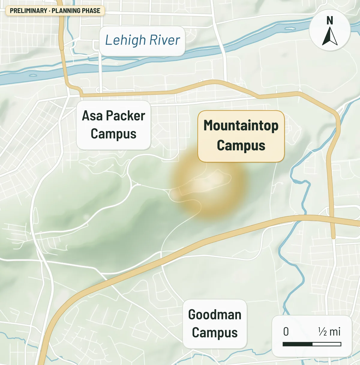
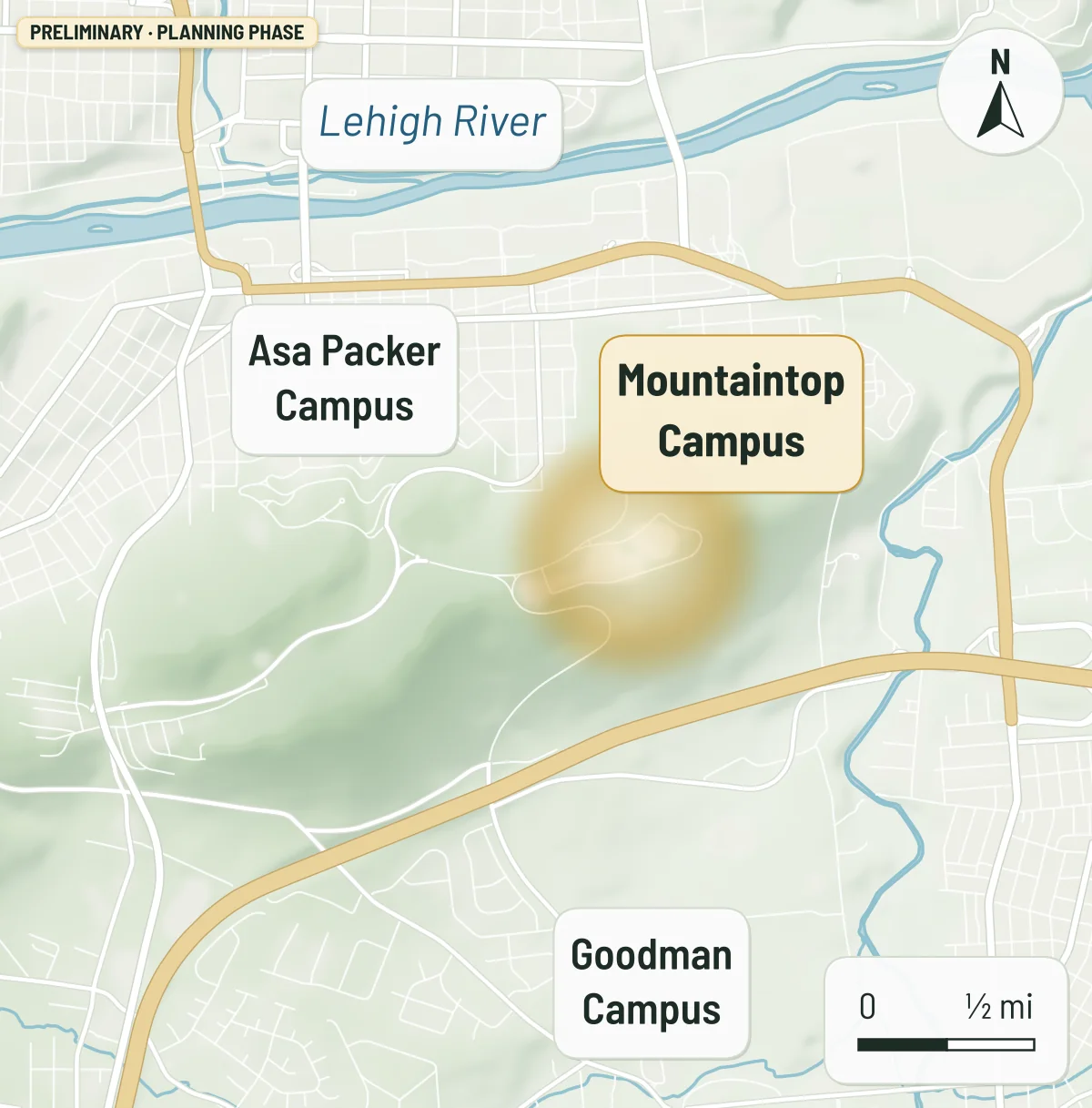
Bethlehem, Pennsylvania, United States
Lehigh University’s Mountaintop Campus
Local rules to check
- Permission to use the land: Needs the landowner's written permission first.
- City zoning and permits: To research, with the landowner's facilities office.
- Soil testing before growing food: To research: which tests suit a former industrial site.
- Food safety for shared produce: To research: Pennsylvania's rules and any partner's own.
- Water connection: To research with the landowner.